Меню
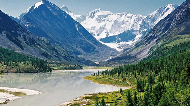
Brief information about tourism in the Katon Karagay district
In the field of tourism, Katon-Karagay district is a rapidly developing region of the East Kazakhstan region. Despite the fact that the area agricultural, the tourism industry is developing in the area. Formation of regional tourism infrastructures and creating a tourist image are important areas of development of the Katon-Karagay region
Everyone knows that our Altay is the birthplace of the Turkic people. On the territory of the district there are historical mounds, petroglyphs and monuments that are witnesses of our history. The nature of Altay is diverse. Namely, clear waters, noisy rivers, enchanting lakes, healing springs, as well as historical finds attract all the peoples of the world.
Snow-capped mountain peaks with fantastic rock formations, dense cedar forests, clean springs, turbulent rivers, waterfalls and ponds, animals, birds and a beautiful multi-color landscape with bright wildflowers make everyone who has visited the region admire and admire.
Mother Nature has endowed with such magnificent sights as: Mount Muztau, Kyndyk tas, Berel’ burial mounds, abandoned high-altitude mine Kokkol, thermal springs Rakhmanovsky Klyuchi, lake Kokkol Rakhmanovskoye, Yazevoye, Ushkol, Maralie. Kaumysh, Bukhtarminsky, Yazevoy Kokkolsky and Rakhmanovsky falls, as well as the northern branch of the Great Silk Road, which is known as the Golden Branch of the ancient caravan route, and the Austrian road, which has historical value as a kind of monument.
In the program article “A View into the Future: Modernization of Public Consciousness”, President N.A. Nazarbayev initiated the creation of the project “Spiritual Shrines of Kazakhstan” (“Sacred Geography”), within the framework of which a cultural and geographical belt of shrines was created. The Sacred Kazakhstan Center of the National Museum of the Republic of Kazakhstan has defined a list of 100 national sacred objects of Kazakhstan. The list of 100 sacred places of Kazakhstan from the Katon-Karagayi region includes 2 objects, as well as the Berel burial mounds and the city of Muztau. These are especially revered monuments of natural and cultural heritage that have lasting value in the memory of the Kazakh people and act as a symbol of national unity and rebirth.
As part of its programme article of the Head of State of the President of the Republic of Kazakhstan “Contribution to the Future Modernization of Public Consciousness under the project“ Spiritual Shrines of Kazakhstan ”and“ Sacred Geography of Kazakhstan ”, the Sacred Map of VKO was developed, where 4 sacred places are designated on the territory of the Katon-Karagay region: these are Berel barrows, Kyndyk Tas, Mount Muztau and Rakhmanov Lake and 1 natural attraction – “Lake Balance”.
Tourism resources of Katon Karagay region :
Muztau (Top of the East)
Geological object of the nature reserve fund. since time immemorial, a magnet has attracted tourists from all over the world. The highest peak of Altai and Siberia (4506 m) Mount Muztau is located on the border of Kazakhstan and Russia, in the north-east of the Katon-Karagai region of the East Kazakhstan region. Muztau has two peaks, in the form of irregular pyramids, East (4506 m) and West (4435 m), between which there is a lowering - “Belukha Saddle”, 4000 m high.
This is the kingdom of snow of ice, formidable avalanches and sparkling waterfalls. The slopes of its two-headed peak are covered with eternal snows and glaciers. Belukha glaciers originate from the Belaya Berel and Katun rivers.
“Dwelling place of the gods”, “Great old man” - this is how the Altai call it. And as N.K. Roerich puts it, this is a mountain about which even deserts are whispering. The name comes from the abundant snow covering Belukha from the top to the very bottom. Travelers contemplating the greatness of the sparkling double-headed peak speak of its unearthly beauty, an amazing change of colors at sunset, the amazing proximity of the sky, in the vibrant twinkling of stars.
Arasan Waterfall
Location: Arasan Valley, 6 km below the resort village of Rakhmanovskiye Klyuch, Katon-Karagai region. The waterfall forms Arasan (Rakhmanovka), flowing from the Rakhmanov Lake. The upper stage of the cascade, the longest and highest, is particularly impressive. In this part, a turbulent stream of water with noise and splashes erupts into a low cliff and, with a wide (up to 5 m) rapid stream, rushes down with a deafening roar, breaking on the rocks and turning into white foam and small splashes. The height of the fall and the flow width of this stage are about 6 m .
Yazova Waterfall
The location is 2 km below the exit of Yazovaya from the lake of the same name, 10 km north-west of the village of Karaairyk, Katon-Karagai district. The channel cut as a result of centuries-old work of the water stream has an unworked profile. In it, one after another, small ledges form waterfalls, rapids and waterfall plums. In total, there are about a dozen cascades here, which, replacing each other, meet at a distance of about 200m. The total height of their fall reaches 10-12 m. Actually a waterfall can be called only the highest step, reaching 5 m in height.
Rakhmanovsky waterfall
Location: The right side of the Arasan valley, 1.8 km southeast of the resort village of Rakhmanovskiye Klyuch, Katon-Karagai region. This stream originates from a small alpine (2265m above sea level) moraine lake and flows into Rakhmanov Lake. Rakhmanovsky waterfall is one of the cascade type waterfalls.
Bukhtarminskoe lake
Location: 38 km north of the confluence of the Shindagatuy river with the Bukhtarma river (Ust-Chindagatuy border post), Katon-Karagai district. Lake Bukhtarminskoye is quite well known in these parts of the country for good fishing on grayling and its picturesque landscapes. In general, the lake is distinguished by good nature conservation and picturesqueness.
Yazevoe Lake
Location: 12 km north of the village of Yazovka, Katon-Karagai administrative district of the East Kazakhstan region. Brief characterization: Lake Yazevoe - a picturesque lake on the approach to Belukha from the south-west side. Its size is relatively small: 1.0x0.4km. Around there are mountains covered with coniferous forests, passing to the top in alpine meadows. It offers a magnificent view of Belukha, which in clear weather is reflected in the lake. The lake is famous for good fishing, as its name suggests. This is the only lake in the region where ides are found, reaching 3kg.
Scientific, cultural and practical value: The lake is located on the main path to Belukha, the upper Beliy Berel, where the rafting starts, to the Kokkolsky waterfall and the Kokkol mine. Lake Yazevoe is located at an altitude of 1685 m above sea level. Its length is 3 km, width 800 m, depth reaches 10 m. The color of the water is yellowish-green, transparency 4.2 m. Two small nameless tributaries and keys flow into the lake, and the Yazevaya River flows out.
Lake Rakhmanovskoe
The Rakhmanov Lake is striking in its beauty, located among steep wooded mountain slopes at an altitude of 1760 meters above sea level.
Near it there are thermal water outlets with a temperature of plus 22-43 degrees C '. The Upper Arasanka River flows into the lake and the Lower Arasanka (Rakhmanovka) flows out. More than 20 million cubic meters of water are accumulated in Rakhmanov Lake. Its area is 1.14 sq. Km, length -2.6 km, width-0.6 km. the coastline is -5.6km.
The water of the lake is a beautiful greenish-blue color, transparency reaches a depth of more than 7 meters. In the summer, the surface layers do not warm above 10-12 degrees. The bottom water temperature is about 4.5 degrees. Such a low temperature is explained by the high mountain position and the relatively large depth (maximum depth of 30.6 meters) of the lake, as well as the influx of water from the cold springs into it. The lake is flowing, fed by the water of rivers and snowmelt. High mountain ranges surround the lake from three sides.
Lake of equilibrium
In the upper Belaya Berel, a small lake of Equilibrium was sheltered in a grand circus. The circus on the slopes of the three peaks Vera, Nadezhda, Lyubov is located directly opposite the Belukha massif. Lake Balance is formed by melting glaciers, it is not very far from the Lower Camp at an altitude of 2400m in a bowl between the peaks of Vera 2591m.- on the right, Nadezhda 2709m.-on the left, Lyubov 3093m.- in the center (the steepest and most impregnable) . The Lake of Balance seemed to freeze in indecision in the intermountain basin. It seems like it is worth breaking a delicate natural balance, and all the beauty will instantly collapse, crumble into small parts and will not return anymore. From the Lake of Equilibrium there are beautiful morning views of Mount Belukha and Belukha is reflected in clear weather.
Austrian road
The name is Austrian, which is not official, the road received from the fact that it was built in the period from 1914 to 1961. Austrian (Czech) prisoners of war of the First World (Imperialist) war. It can be considered as a monument to the heroic work of Man, who in those years was able to create this monument with the help of simple tools - shovels and picks. Today it’s even hard to imagine that the track at an altitude of more than 2000 meters above sea level, with a length of about 150 km, could be laid with a pickaxe and a shovel in hand. They say that people died countless here: those who fell down, those who were overwhelmed with stones, and those who could not stand the excessive load.
Northern Branch of the Great Silk Road (Golden Branch)
The Northern Golden Branch of the Great Silk Road is an ancient caravan route connecting the Central Asian Regions of Mongolia and China with Irtysh, and further west and south to the most significant antiquity markets. Today, this direction has remained within the Katon-Karagai State National Natural Park. (KKGNPP).
Within the national park, this path is a very picturesque area. Especially within the village of Arshaty is the Ukok Pass. Here, the road runs along the Bukhtarma River, which has a stormy, mountainous character in these places. The left side of the valley is steep and densely covered with coniferous forest, above which the snowy peaks of the Southern Altai ridge rise, reaching almost 3800 m above sea level. The right side of the valley is composed of low mountains with sparse coniferous forests and meadows. Above the confluence of the Chindagatuy River, an alpine larch forest appears, passing on the Ukok plateau to the alpine steppes and tundra. It is no less picturesque even within the Ukok plateau. Along the road there are a large number of ancient graves of various ages and origin. This Northern Branch of the Great Silk Road is rightly called the Golden Branch. Gold and bronze of Altai, gold of Scythians and Arimasp to the East and West went along it. A large number of archaeological finds of world significance were made in the Russian part, in particular, the famous Pazyryk excavations (in the Russian part of the road) and the Berel excavations in the Kazakhstan part. Historical analysis and interpretation of the Northern Branch of the Great Silk Road are still waiting for their researchers, but now they are confident we can say that it is of great cultural, historical and natural-aesthetic value, which has global significance.
Routes Active tourism
Mountaineering
In our area the peak of the highest mountain Belukha (4506m) sparkles in Siberia and Altai. Here is the kingdom of snow, ice, rumbling avalanches, sparkling waterfalls - the kingdom of the mountains. Climbing to Belukha means to be ordained as a climber, to prove your own fearlessness and good physical shape. Altai mountains are visited annually by a large number of alpenists from different parts of the world. The Katunsky ridge with numerous routes to the mountain peaks, including steep and long rocky, ice and snow slopes, ridges or couloirs, as well as various combinations of such sites. You will be able to make an ascent from the south side, "closed" earlier for foreigners.
Water tourism
In the past few years, raftin has become increasingly popular on the Berel River. Modern alloy tools and professional equipment, as well as competent instructors, minimize the risk of passing thresholds. They are quite dangerous, so we do not recommend rafting without special training. If you still want to taste the risky flight of mountain rivers, contact a travel agency specializing in this sport, and you will get this opportunity with an experienced instructor.
Hiking
Hiking is one of the most popular types of tourism. The best time for hiking is June-August .. The entertainment of the routes, the richness of flora and fauna, the richness of various reservoirs will satisfy any contemplative reguests. A height difference, length and complexity of the routes is of considerable sporting interest.
- Tracking “To the foot of the Belukha”, the duration of the route is 9 days, the length is 95 km., Uncategorically difficult hike runs along the valley of the river. Belaya Berel with a visit to the Kok-Kola Falls (drop height 42 m.), the base camp on the Berelsky Glacier, old abandoned mines on the Kok-Kola Pass.
- Tracking “Altai Trails”, the duration of the route is 7 days, with a length of 100 km., Includes the passage of 2 passes, alpine meadows, the legendary Belovodye, the passage of 3 mountain rivers, the Kok-Kol waterfall.
- Tracking “Emerald Ring”, duration 8 days, with a length of 105 km., includes a visit to the lake Yazevoe, Kok-Kol pass, lake Coksu, Black Berel River.
Car tourism
This type of tourism passes not only in the Katon-Karagai region, but in the East Kazakhstan region. The duration of the basic program is 7 days. Transfer: Ust-Kamenogorsk - Sibinskie Lakes - tract Kiin-Kerish - Markakol Lake - sanatorium "Rakhmanovskie Klyuchi" - Ust-Kamenogorsk (1200 km.).
Equestrian tourism
On hardy horses you can get to where the car does not reach, and walking will be difficult to access. Participants of the routes have the opportunity to visit places farthest from the settlements, which contributes to the close contact of people with the untouched and unique nature of the mountain regions, good and healthy rest. Horse trekking routes can go along any roads, forest and mountain trails, and also without roads - along steppes, meadows and fields, through fords and ravines, along the banks of rivers and lakes.
Rural tourism
In the villages of Uryl, Berel, Yazevoe, Akmaral, horseback and walking tours in the surroundings are accompanied by a guide, visiting craftsmen, where you can buy souvenirs or favorite products, try Kazakh national dishes. You can go fishing, picking berries, mushrooms and nuts. You can also see how Kazakh carpets - alashi are made; cooked cheese; knock down kymyz.
The list of tourist sites of the Katon-Karagai region.
In Katon, Karagaysky district there are 9 panthebic clinics, 2 sanatoriums,
Sanatorium "Rakhmanovskie Klyuchi"
Lake Rahman, Arasan - this is the thermal water used for treatment in the Katon-Karagai region. Sanatorium "Rakhmanovskie Klyuchi" is located 450 km. from the city of Ust-Kamenogorsk, not far from the border crossing of Kazakhstan, Russia and China, in the heart of the Altai mountains at an altitude of 1760 m above sea level, between two picturesque lakes at the bottom of a stone bowl. Unique medicinal baths located directly on thermal radon springs from the ground heal from diseases of the musculoskeletal system: arthritis, polyarthritis, various diseases of bones, muscles, tendons, diseases of the spine, rheumatism, radiculitis, diseases of the peripheral and central nervous system, various skin diseases. Of the additional services offered massage, office LCF, physiotherapy, herbal medicine. The sanatorium consists of medical buildings, a dining room and cozy residential cottages. At the sanatorium there is a rental of boats, catamarans, horses for horseback riding.
Location: Katon-Karagaysky district, in the southeastern part of the village Topkain, 0.5 km. off the road. Main activity: Wellness (which includes: climatotherapy, complex therapy, herbal medicine, sauna therapy, wellness massage, acupuncture treatment, bioenergy correction, gym), Sports, with sports fields and gyms, Tourist (which includes horse riding, mountain biking, hiking , auto tours, skiing, snowmobiling, combined routes) - are designed in such a way as not only to give athletes the opportunity to train and everyone who wants to play sports, but also reduce those leg load, and at the same time bring the most effective healing effect. The developed programs make it possible to combine passive and active types of physical education and sports with complexes of health-improving medical procedures suitable for people of various ages. The complex operates year-round, meets all modern requirements for professional and amateur sports, recreation, satisfies the needs of different social groups. It creates an additional impetus in the economic development of the region, creates new jobs, and contributes to the development of the organization of health and recreation.
"Bayan"
Location: Katon-Karagai district, village Katon-Karagay. The main activity: wellness (which includes: climatotherapy, complex therapy, herbal medicine, sauna therapy, wellness massage). Tourist (which includes: a walk around the places where deer live, horseback riding, hiking, car tours, combined routes). The hotel services are medium and high level.
"Ak Kayin"
Location: Katon-Karagai district, village Katon-Karagay. The main activity: wellness (which includes: complex therapy, herbal medicine, sauna therapy, wellness massage). Tourist (which includes: a walk around the places where deer live, horseback riding, hiking, car tours, combined routes). The hotel services are medium and high level.
"Abzal"
Location: Katon-Karagaysky District, 12 km. from village Novo-Polyakovka. The clinic is located in a picturesque natural area 60 km. from the district center, for the races takes about 12 people. Main activity: antler recovery (which includes: complex therapy, sauna therapy). Tourist (which includes: a walk around the places where deer live, horseback riding, hiking, combined routes). 3 middle and high level hotel services are provided. There are 8 baths.
The recreation center "Valley of the Kings"
The recreation center “Valley of the Kings” is located in the Katon-Karagai region in the foothills of Belukha, the highest peak in Altai. The pacification of greatness - these are the first sensations when you get acquainted with the Valley of the Kings. On the territory, there are two residential cottages, a VIP cottage, a dining room, a pantheclinic, two saunas, a billiard room. At the same time, no more than 10-15 people can stay at the base.
"Katon-Karagai Deer Park"
The clinic is located in the Katon-Karagai region in the village of Akmaral. It began its activities in 2006. Capacity 25 people. Main activity: antler rehabilition (which includes: complex therapy, sauna therapy). Tourist (which includes: a walk around the places where deer live, horseback riding, hiking, combined routes). On the territory there are cottages, VIP cottages, a dining room, a pantheclinic, two saunas, a billiard room. At the same time, the base can provide hotel services of medium and high level.
"Aksu"
The clinic is located in the Katon-Karagai region in the village of Aksu. It began its activity in 2003. Capacity 35 people. Main activity: antler rehabilition (which includes: complex therapy, sauna therapy). Tourist (which includes: a walk around the places where deer live, horseback riding, hiking, combined routes). On the territory there are cottages, VIP cottages, a dining room, a pantheclinic, two saunas, a billiard room. At the same time, the base can provide hotel services of medium and high level.