
Earth Remote Sensing Space System
Сипаттамасы
As the world practice shows, remote sensing systems of the Earth surface are in high demand among a wide range of consumers - both in public and private environment. Information received by means of space satellites and systems is applied to the analysis, improvement of activity and the decision of problems in different spheres and branches: agriculture, defense and security, emergency prevention, environmental and natural resource management, land use, geodesy, cartography and other areas of life not only for individual enterprises, cities and regions, but also for sectoral ecosystems.
The Kazakhstan Earth Remote Sensing System is no exception: The high demand prior to the creation of the Earth Remote Sensing system was confirmed by the large number of tasks that had become possible thanks to the launch and use of the space remote sensing system.
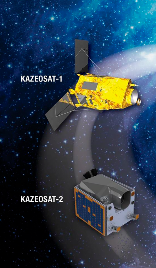
The domestic ERS system consists of high spatial resolution "KazEOSat-1" and medium spatial resolution "KazEOSat-2" satellites, as well as ground-based complexes for satellite control and reception, processing and distribution of ERS data directly to consumers. Kazakhstan's ERS system has been operating in normal operation for 5 years. The system operation is provided by Kazakhstan specialists who have undergone training at the leading European aerospace industry enterprises.
Space images taken with the help of satellites can be ordered at eo.gharysh.kz.
Satellites
The Earth Remote Sensing Space System (ERSSS) comprises two optoelectronic spacecraft: high spatial resolution (1m) of "KazEOSat-1", medium spatial resolution (6.5m) of "KazEOSat-2", as well as ground-based satellite control complex and ground-based target complex for receiving, processing and distributing remote sensing data to end users.
On April 30, 2014 the first Kazakh high-resolution remote sensing satellite KazEOSat-1 was successfully launched from Kourou Cosmodrome (French Guiana).
The launch of KazEOSat-2 medium resolution remote sensing satellites took place on June 20, 2014 from the Russian launch base "Yasnyi" (Orenburg Region, Russia).
As part of the contract on ERSSS of Kazakhstan, Kazakh specialists were trained and technologies were transferred for design, production, assembly, testing and operation of spacecraft.
Space monitoring results for 2018
|
Agriculture |
Forest resources |
|
Digitized agricultural land - 35.3 million hectares (100%) |
Digitized forest land - 17.6 million hectares (100%) |
|
Water Resources |
Wastes from production and consumption |
|
Digitized water bodies |
Digitized license areas (in fact) |
|
ED |
Prosecutor General's Office |
|
Digitized - 297 fire units. |
In 2018-2019, using a geoportal, the prosecutor's office identified more than 37 thousand unused land plots with an area of 9.6 million hectares and a cadastral value of 700 billion tenge. |
Результаты космического мониторинга за 2020 год
|
Сельское хозяйство |
|
|
По растениеводческой продукции: Оцифровано сельхозугодий - 35,8 млн га (100%) - состояния посевов; По пастбищным угодьям 8 районов РК: Оцифровано пастбищных угодий - 16,8 млн га; Оценка: - состояния степени деградации и продуктивности пастбищной растительности по сезонам года (весна, лето, осень). По рациональному использованию земельных ресурсов: Выявлено по 6 исследуемым областям 1 023,9 тыс. га неиспользуемых земель, 367,8 тыс. га неучтенных пахотных земель |
|
|
Недропользование |
Лесные ресурсы |
|
Выявлено: - 68 недропользователя осуществляют свою деятельность без нарушений площадью 484,18 га - 21 недропользователей осуществляют свою деятельность с нарушениями границ - 76 недропользователей не осуществляют работы на участках |
Оцифровано лесных угодий - 18,6 млн га (100%) - лесистости территорий |
|
Водные ресурсы |
Отходы производства и потребления |
|
Оцифровано водных объектов Мониторинг сезонно: |
Выявлено: - 8 884 места образования стихийных свалок Зафиксировано - 299 свалок с нарушениями лицензионных границ Произвели обновление мобильных приложений WasteEdit, Wasteviewer, «Oko KZ» Ликвидировано: - 7579 несанкционированных свалок |
|
ЧС |
ГенПрокуратура |
|
Выявлено: – 214 373 очагов пожаров, 4 915 возгораний - площадей выгоревших территорий; |
Произвели обновление мобильных приложений GenProEdit и GenPro View, с картографической базой Изъято или вовлечено в оборот 12,5 тыс. участков общей площадью 6 млн. га Оценка: - динамики изменения границ лицензионных и контрактных территорий - выявление фактов проведения операций по недропользованию |