Меню
General information
Aktobe region belongs to the western regions of Kazakhstan. It is the largest region of the country, with an area of 300.6 km2.
At the same time, the average population density in the region is the lowest in Kazakhstan, only 2.7 people per 1 km2.
The peculiarity of the geographical location of the Aktobe region lies in the fact that both its northern and southern borders are external. In the north, the region borders with the Orenburg Oblast of Russia, and in the south – with the Karakalpak Autonomous Oblast of Uzbekistan.
At the beginning of 2023, the population of the region amounted to 928.2 thousand people. City inhabitants form a majority of the population –74.6%, while rural residents amount to 25.4%.
According to statistical data, 84.3% of the population of the region are Kazakhs, Russians are in second place – 10.4%, Ukrainians are in third place, the share of which is 2.1%.
Administrative division
The administrative center of Aktobe region is the city of Aktobe, the largest of the cities of Western Kazakhstan. In total, there were 8 cities and 315 rural settlements in the region at the beginning of 2023. The territory of the region is divided into 12 districts.
In addition to Aktobe, which has a population of 560.0 thousand people, the significant cities of the region are Kandyagash (35.6 thousand people), Khromtau (30.0 thousand people), Shalkar (28.0 thousand people) and Alga (22.7 thousand people).
Regional center
Aktobe city, located in the north of the region, is on the left bank of the Ilek River, one of the tributaries of the Ural River. The territory of the city administration includes a city with a suburb consisting of five rural districts.
Aktobe came about from the Aktobe fortress (which translates from Kazakh as "White Hill"), founded in 1869. In 1891, the garrison fortification of Aktobe was transformed into the county town of Aktubinsk, Turgai region. On March 10, 1932, Aktubinsk became the center of the Aktobe region of the Kazakh SSR.
On March 11, 1999, by Decree of the President of the Republic of Kazakhstan, the town of Aktubinsk became known as Aktobe.
History of the region
Aktobe region was formed on March 10, 1932, its regional center was already a fairly large city of Aktubinsk by that time, with Orenburg-Tashkent railway passing through the territory of city. Initially, the region included 17 districts, some of which were subsequently transferred to the Kostanay and Kyzylorda regions.
After Kazakhstan gained independence, the composition of the districts of the Aktobe region was finally adjusted and remains unchanged to this day.
Natural and climatic conditions
The Aktobe region, having a huge territory, stretches for hundreds of kilometers, which includes various types of terrain, but its territory is mainly flat. The region stretches from the Caspian lowland in the west to the Turan lowland in the southeast and the Turgai Plateau in the northeast and from the southern spurs of the Ural Mountains in the north to the Ustyurt plateau in the south.
Aktobe region is not rich in water resources. Most of the rivers originate in Mugodzhar mountains – these are the southern spurs of the Ural Mountains with the highest point in Ulken Boktybai (657 m). Mugodzhar mountains occupy the northern and large part of the central part of the region, where the Emba, Or, Ilek, Turgay, etc. rivers begin. They are low-water rivers and often dry up by autumn. Lakes are also seasonally filled for the most part. The largest lake in the region is the salty lake Shalkar.
Due to the large area, the Aktobe region covers several natural zones at once: dry-steppe, semi-desert and desert. In the north-west, the steppe consists of various types of feather grass and wormwood grass. The central and north-eastern parts are occupied by the grain-desert steppe, in the south there are sagebrush-salt deserts. The peculiarities of the fauna of the region are determined by the specifics of these natural zones.
The subsoil of the Aktobe region is rich and diverse, there are 340 different deposits. All reserves of Kazakhstan's chromium, 50% nickel, 40% titanium, 34% phosphorites are concentrated in the region. 10% of the explored and 30% of the forecasted reserves of Kazakhstan's hydrocarbons are located here. Region also possesses large deposits of precious metals, copper, zinc, and petroleum bitumen rocks.
Economy
Aktobe region is an industrial and agricultural region, according to the results of 2022, the gross regional product amounted to 4.3 trillion tenge. Industry occupies the main share in the economy – 40%, trade – 13.4%, transport and warehousing – 8.7%, agriculture – 6%, construction – 5%, other industries – 26.9% (information and communications – 0.6%, health and social services – 2.5% and others).
The region is among the leading industrial regions of the country. The volume of industrial products manufactured in 2022 amounted to 2,779.8 billion tenge, or 101.5% compared to the same period last year.
A number of large mining and manufacturing enterprises are located here. Among them are TNC Kazchrome JSC, Aktobe Plant of Chromium Compounds, Aktyubrentgen, CNPC-Aktobemunaigas JSC, KazakhOil Aktobe, Urikhtau Operating and others.
There is a positive trend in the growth of the share of manufacturing industry in the overall industrial structure of the region: from 37.4% in 2021 to 42% in 2022.
The volume of agricultural production in 2022 amounted to 443.1 billion tenge or 106.6% compared to the same period last year.
In order to increase the incomes of the rural population and ensure food security in the region, the "Auyl Amanaty" project is being implemented, within the framework of which residents of villages and small towns can receive financial and commodity loans on favorable terms for them.
The volume of investments attracted to the region in 2022 amounted to 959.1 billion tenge, which is 10.1% more than in the same period last year.
Tourism
Aktobe region has a great potential to attract fans of eco-tourism. The Irgiz-Torgai Reserve is located on the territory of the region, where the Betpakdalinsky saiga lives. An attractive route is a boat trip through the system of the Malaidar lakes, which are united by the Irgiz River.
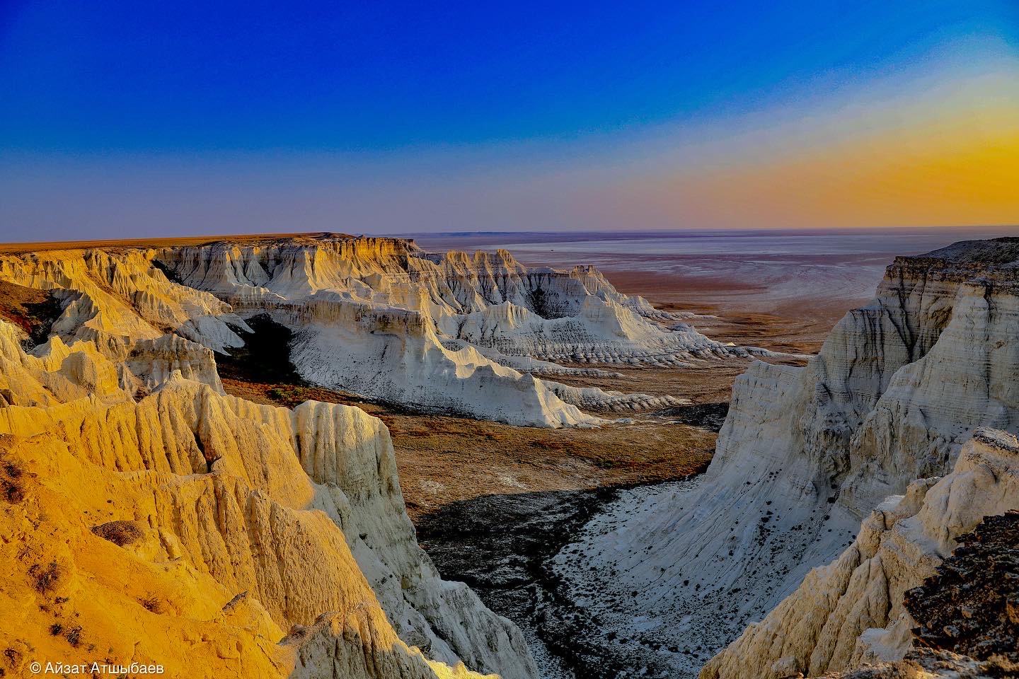
A unique combination of beautiful nature and traces of geological processes can be seen on the Aktolagai plateau, as well as in the Zhamanshin meteorite crater.
As for historical monuments, these are, first of all, the mausoleum of Abat-Baytak, the mausoleum of Koblandy batyr. Tourists can see the historical heritage of the region in the local history museums, which are almost in all district centers. In 2015, 19 museums of the region contained about 90 thousand exhibits from the fund of a museum.
Website of Akimat of Aktobe region https://www.gov.kz/memleket/entities/aktobe?lang=en