Меню
General information
Ulytau region (Ūlytau oblysy) - region in the central part of Kazakhstan, formed on June 8, 2022. The administrative center of the region is the city of Zhezkazgan.
On March 16, 2022 the President of the Republic of Kazakhstan Kasym-Jomart Tokayev during the joint session of the Parliament stated that Ulytau region will be formed from a part of Karaganda region.
Ulytau region borders Turkestan region in the south, Kyzylorda region in the south and west, Zhambyl region in the south and east, Aktobe region in the west, Kostanay region in the north and west, and Karaganda in the north and east.
The population of the region as of March 1, 2023 amounted to 221.5 thousand people, including 175.2 thousand people (79.1%) - urban, 46.3 thousand people (20.9%) - rural residents.
The largest cities of the region are Zhezkazgan city with a population of 92,992 people, and Satpayev city with a population of 68,797 people.
Administrative division
The administrative center of the region is the city of Zhezkazgan. The territory of Ulytau region includes 2 rural districts. There are 3 cities, 2 settlements and 72 villages on its territory.
Regional center
The city of Zhezkazgan is located in the basin of the Kara-Kengir River, south-east of the Ulytau Mountains, where the Kara-Kengir River and its tributaries originate, as well as the Sary-Kengir, Zhylandy and Zhezdy, flowing into the Sarysa River, at the north-western end of the Hungry Steppe (Betpak-Dala). It is located on the conditional border of desert and semi-desert zones.
It was founded in 1939 as a labor settlement in Kengir, in 1941 it was renamed into Bolshoy Zhezkazgan. December 20, 1954, by decree of the Presidium of the Supreme Soviet of the Kazakh SSR working settlement of Bolshoy Zhezkazgan received the status of a city.
In 1973-1997, Zhezkazgan region existed within the Kazakh SSR and Kazakhstan, which as a result of administrative reform in 1997 became part of the Karaganda region.
Zhezkazgan is considered as the copper city, a major center of non-ferrous metallurgy of Kazakhstan.
In the vicinity of the "copper capital", so poetically called Zhezkazgan, there are several mausoleums of Mongol and Kazakh khans of medieval and new times, including the mausoleum of Alasha Khan, Juchi-Khan, Dombauyl, Bolgan Ana, as well as other sacral places such as Altyn Shoky, "Kalmakkyrylgan" (Bulanty), Terekti-Auliye and other historical monuments.
The main water resources of the city are Kengir reservoir (37 km²) on the Kara-Kengir river and Zhezdy reservoir to the south of the city. The city has a huge industrial, transportation and intellectual potential.
History of the region
Ulytau region is considered as the central part of Kazakhstan, formed on June 8, 2022. In 1973-1997 there was Zhezkazgan region within the Kazakh SSR and Kazakhstan, which as a result of administrative reform in 1997 became a part of Karaganda region.
On March 16, 2022, the President of the Republic of Kazakhstan Kasym-Jomart Tokayev during a joint session of the Parliament stated that the Ulytau region will be formed from a part of the Karaganda region.
The region consists of Zhanaarka and Ulytau districts and the cities of Zhezkazgan, Satpayev and Karazhal.
In the 18th century, the territory of the Ulytau region was inhabited by tribes of the Middle Zhuz: Argyns (subgenera Karakesek and Atygay), Naimans (subgenera Baganaly and Baltaly), Kypshaks (subgenera Bultyn, Uzyn and Tory), and the Zhana-Kyrgyz tribe, which was not included in the Zhuzes.
Natural and climatic conditions
The climate is semi-desert (sharply continental), dry. The territory is exposed to dust storms. Winters are cold and summers are hot and dry. Springs are short and falls are long.
High degree of continentality and sharply pronounced dryness are explained primarily by remoteness from oceans and seas. Duration of vegetation period and amount of solar heat allow cultivation of many agricultural and melon crops.
The absolute maximum temperature is 45.1C, the absolute minimum temperature is -41.1C.
Economy
The economy of Ulytau region is determined by industry, the level of development of which is the main indicator of its socio-economic condition and stable social climate.
According to the results of 2022, the total volume of industrial production amounted to 1 trillion. 56 billion tenge, IFO - 102.7%.
The manufacturing industry amounted to 844 billion tenge, IFO - 103.2%.
In the mining industry - 159 billion tenge, IFO - 102%.
Stable activity of backbone enterprises “Kazakhmys Corporation” LLP, Zhairemsky mining and processing plant, the project “Orken” LLP is launched in 2021 with investment of 25 billion tenge. Since the beginning of this year, the volume of these enterprises amounted to 227 billion tenge or 78% of the total industrial output.
Tourism
In December 2021, the National Natural Park Ulytau was established by the Decree of the Government of the Republic of Kazakhstan.
The created National Natural Park will serve as a protection of the unique ecosystem preserved here and another point of attraction for tourists.
Today, there are 5 tourist routes leading to sacral places of the region, such as Zhoshy-Khan, Alasha-Khan, Dombaul, Khan-Ordasy, Aulie-tau and others.
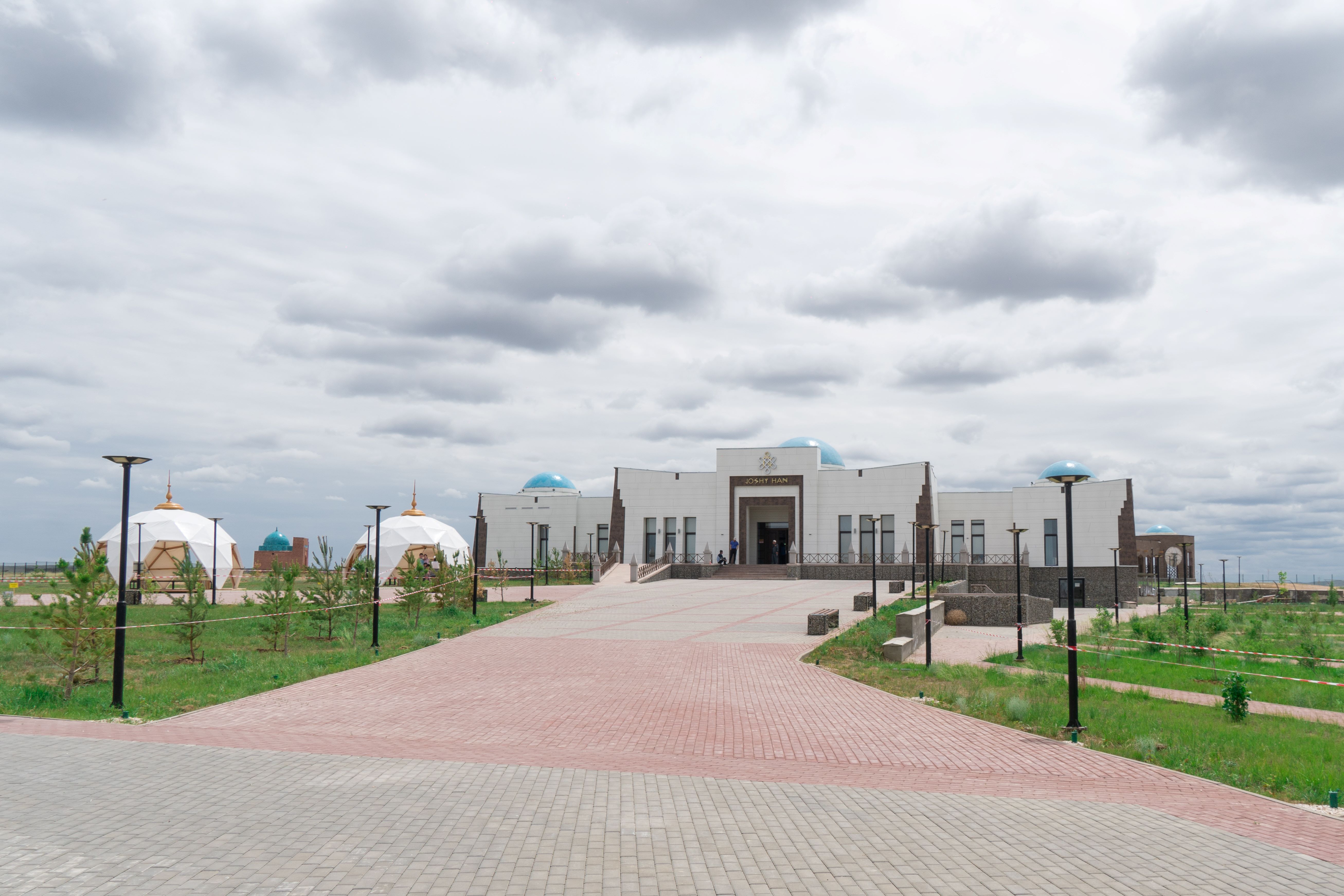
Last year the historical and cultural complex "Zhoshy Khan" near the mausoleum of Zhoshy Khan was put into operation at a cost of 1.3 billion tenge. The complex occupies an area of two and a half thousand square meters. It includes an exhibition hall, hotel, museum in 3D format, ethno-aul with yurts, tents for exhibitions and sale of national products and jewelry. In June 2022, the first meeting of the National Kurultai with the participation of the Head of State was held in the complex. In 2022, more than 14,000 people have visited the complex "Zhoshy Khan" since its opening.
In addition, to improve the tourist attractiveness of the Ulytau region, it is planned to develop roadside services, including the installation of sanitary and hygiene units, construction of cafes and camping sites along tourist routes.
In general, the newly established region has great potential in the tourism industry and one of the priority directions in the activities of the City Hall (akimat) of the Ulytau region will be aimed at the development of tourism support.
Accommodation services were provided by 29 facilities In January-June 2022 in the Ulytau region. They have 355 rooms with a single capacity of 646 beds. The number of served visitors in accommodation facilities in January-September 2022 amounted to 19.9 thousand people.
Sacral monuments of Ulytau region
Aulietau Peak (Akmeshit)
Aulietau (Akmeshit) is the peak of the Ulytau Mountains. "Ulytau" is translated as "great mountain" or "big mountain" from Kazakh. But since these mountains themselves are actually not very high, this name rather has a sacred meaning, since these mountains are "the main revered mountains" in which the shrines of nomads have been hidden since ancient times. There are ancient burials in Aulietau.
According to legend, the prophet Zarathustra was born in these mountains, moreover in the Middle Ages Zhoshy Khan, Alasha Khan, Tokhtamysh Khan, biy Yedige and other prominent ancestors were buried here. History preserves the memory of ancestors, and descendants always honor it. These sacred mountains are carriers of ethnic memory and greatness. The people, like the earth, do not know old age. In the history of the Kazakh people and the ancient Turks – these mountains played an important role. An ancient legend about six Alash tribes – the supposed ancestors of the Kazakhs - is also connected with them. The history of the formation of the Kazakh nationality and the formation of a single Kazakh people can not be separated from the history of these places. These mountains are witnesses and participants of all the most important stages of the history of the Kazakhs. Perhaps that is why the people respectfully called them Ulytau – "great mountains".
Within a radius of 40-60 km from the sacred peak of the Ulytau massif - 9 khan's stakes are located in Aulietau mount, as if outlining the circle of the protected area, the oral creativity of the local population brings to us that the Ulytau mountains are not only the highest point of the western Saryarka, but also its navel, the point where creation has its beginning – the root, the "center of the world". According to legend, the peak is closest to the sky, where heaven and earth meet, so since ancient times the mountain was considered as a sacred place, the abode of God and spirits, a place of constantly operating sacred forces, a place of ritual behavior and human connection with nature. The ancient inhabitants of Ulytau sacralized this place for certain reasons, understandable to them at the level of deep subconscious thinking. As a rule, this place has operated according to its ritual laws since ancient times. Having once chosen this place for worship, people have been coming to it for many centuries to perform their rituals. This tradition continues to this day.
Edyge Peak
The peak of Edyge is located 35 km west of the village of Ulytau. On its top is the burial place of the famous Khan of the Golden Horde Tokhtamysh (Toktamys). On the top of the sacred Ulytau, the respected biy Yedyge was buried, whose name later became the mountain. He was a contemporary of Khan Tokhtamysh, who ruled the Golden Horde in 1380-1395, the central cities were the cities of Sauran and Syganak. Teaming up with Tokhtamysh, they conquered the lands from the Volga and the Urals and became the founders of the Nogai Horde.
In 1396, they ruled the Golden Horde and strengthened the Nogai Horde. In the folk tales of Kazakhs, Karakalpaks and Bashkirs, the name of Edyge is found as the name of the founder of the Nogai Horde.
In the "years of troubles'' (1410-1412) in the Golden Horde, Edyge lost his dominion. Power passed to the sons of Tokhtamysh again. In 1419, the son of Tokhtamysh Kadyrberdy killed Edyge in Saraichik.
The body of Edyge was buried in the Ulytau mountains, having a tombstone installed over the grave. Since then, the places "Mount Edyge", "Grave of Edyge" have appeared here. The birthplace of Edyge itself is the locality of Ulytau, namely Kishitau (small mountain). His destiny to be a leader and manager manifested itself in his youth. From the legends that have come down to us, you can understand and see his courage and bravery, intelligence and foresight. He was not afraid to tell the truth to the khan, he was truly a leader, an orator, a sage, so they always talked about him as a hero. In oral folk art there are such lines: "Edyge degen er eken, Eldin kamyn zher eken. El shetine zhau kelse, men barayyn der eken" - "there is a batyr Edyge who always cares about his people. If the enemy comes, he will be the first to defend his homeland."
Under the shadow of Ulytau, many centuries ago, historical events that became turning points in the history of the Kazakh people unfolded, here, according to tradition, the proclaimed khans were raised on a white cat, and the Khan's headquarters itself – Khan Ordasy was located here. In Ulytau, according to legend, the famous storyteller Asan Kaigi found the land of dreams – Zheruyyk.
The rebellious souls of the rulers of the Golden Horde Tokhtamysh and biya Edyge, whose names and deeds are mentioned in the epics of the peoples of the Altai, the Urals, the North Caucasus, the Crimea, and Uzbekistan, rested forever in the mountains of Ulytau. Kazakhs are well known for the epic poems "Tokhtamysh" and "Edige", included in the cycle-book of the outstanding steppe singer-storyteller Muryn-zhyrau (died in 1949) "Forty Batyrs of the Crimea".
The Russian ethnographer Grigory Potanin, who collected folk tales about Edyga, noted that during his reign the people lived in prosperity and prosperity. According to Alkey Margulan, much about Edyga can be learned from the works of the Arab writer ibn Arabshah. In particular, that his descendants lived in Kumkent.
Dombauyl Mausoleum
The Dombaul Mausoleum is notable for being, according to many scholars, one of the most ancient structures that Central Kazakhstan has. It is believed that it was built during the Hun rule and was intended for cult rituals.
The mausoleum is built of stone-slate on clay mortar. The inner room is trapezoidal in shape. The entrance is oriented to the east. One of the largest stone structures in Kazakhstan, built in the pre-Islamic period, in the VIII-IX centuries. It is located on the left bank of the river Karakengir.
There are various legends about Dombauyl. One of them says that he was Genghis Khan's court musician. When Genghis Khan's son Dzhuchi (Zhoshy) Khan died on a hunt, the courtiers were afraid to tell the news to the Shaker of the Universe. Only Dombauyl (according to other legends of Ketbuga) agreed to tell Genghis Khan about the death of his son: he, without saying a word, played the dombra in silence, the formidable Khan understood the language of music and ordered to pour hot lead over the dombra. But there is another legend: Dombauyl was the very dzhigit who killed a herd of kulans, because of which Juchi Khan died. And the third version speaks about a kobyzist musician, whose name is mentioned in the Turkic epic work "Oguz-name". In the monologue of the great zhyrau poet Sypyr Surgaltayuly, who lived in the world for 180 years, in his address to Tokhtamysh Khan it is said:
I've seen the world,
I'm a hundred and eighty years old,
and my soul is still alive in me...
I've even seen Dombauyl,
The fairy-tale sage,
He was known to all the villages,
He was leading the messenger. (translated by O. Zhanaidarov)
Hence, Dombauyl is a fairy-tale, folklore character rather than a historical one.
The fact that the "fairy-tale sage" has not only a burial place, but also a mausoleum of his name, does honor to the architects of the Great Degree and those noble people who care that the names of national heroes and the people's memory of them lived in the centuries....
Altyn Shoky
Altyn Shoky ("Golden Peak") is the name of the mountain Ulytau ridge in the Karaganda region, the history of which is associated with the Great Tamerlane (1336-1405). During the campaign against the Khan of the Golden Horde Tokhtamysh, Tamerlan ordered to erect a huge stone monument on the peak of Altyn Shoky. Legend has it: in April 1391, during the campaign against the Khan of the Golden Horde Tokhtamysh, Tamerlane with 200 thousand troops stopped at the foot of Mount Ulytau in the heart of the Saryarka. The way of the army of the Maverannahr ruler went through the Betpakdala desert. But here, in the estate of Khan Zhoshy, a completely different nature appeared: mountain air and cool rivers, lush pastures and fields. Realizing that the army needed to gain strength, they stopped in this area for a few days. Admiring the nature of the Ulytau region, Tamerlane, as a token of gratitude, ordered the erection of a stone monument on which it was noted that here he stopped with his army.
Information about this historical event became known only six centuries later. The stone set by the great ruler Tamerlan was discovered in 1935 by the famous Kazakh scientist-geologist, the first academician of the Academy of Sciences of the Kazakh SSR Kanysh Satpayev during an expedition through Central Kazakhstan. The stone sculpture, which was a fragment of a huge rock, was found in the Akshoky area of Ulytau district. In 1941 Kanysh Imantaevich published an article "Prehistoric monuments in Dzhezkazgan district", which in 1989 was included in the collection "Selected articles about science and culture" of the publishing house "Nauka". It notes: "according to Yazdi, Timur "climbed to the top of the Ulutau mountains and for a long time enjoyed the view of the surrounding steppe, which was covered with beautiful greenery from one end to the other". Timur spent a whole day here and "ordered his troops to bring stones and built a large pyramid here, on which skillful craftsmen carved the date of this happy event to preserve the memory of it for many years".
The monument is located on the north-western slopes of the Ulytau Mountains, 90 km west of the Zhezkazgan-Arkalyk highway and 80 km west of Sayat village. Its height is 50 meters. The most memorable thing about Altyn Shoky is the pile of stones rising on its top, assembled in the shape of a cut pyramid. Tamerlane ordered his 200,000-strong army to lift one stone at a time to the top of the mountain, build a smelting furnace, chop bushes near the nearby river, light a fire and melt the meteoric stones. And all this in order to leave a commemorative inscription, which is similar to modern Kazakh: "The history of the seven hundred and ninetieth year of the sheep. The summer month of July. Sultan of Turan Temirbek is going with his 200 thousandth army to war with Khan Tokhtamysh. Passing through this area, he left this inscription as a memory: "may Allah bless him! inshallah, may with the blessing of Allah all people remember him".
Despite the discovery of this historical fact, the composition of the material of the inscription has not yet been revealed. This artifact is in the St. Petersburg Museum. Previously, the slab was located above a huge pit where there was a kiln for firing bricks.
An exact copy of the stone with this inscription of the Emir is installed on the top of Altyn Shoky.
Bolgan Ana Mausoleum
The monument of memorial architecture of Kazakhstan is located 10 km above the confluence of the rivers Karakengir and Sarysu, in the tract Karazhar. The mausoleum is a one-chamber, portal-type architectural monument.
The first mentions of the monument are found in the notes of N. Rychkov, A. Levshin, Ch. Valikhanov and others. The mausoleum was finally identified and described for the first time by the famous archeologist A.H. Margulan.
Several versions of legends about Bolgan ana's personality have been preserved in the oral tradition. According to one information, Bolgan ana was the daughter-in-law of the legendary Alasha khan. According to other data, this name was the daughter-in-law of Genghis Khan himself or a wealthy widow of one of the steppe rulers in the period of the XV century.
Mausoleum of Alasha khan
The mausoleum was built by folk craftsmen in the XІ-XІІ centuries in honor of Alash khan. His name is directly connected with the emergence of the three zhuzes of the Kazakh people. One of the famous mausoleums of Kazakhstan is located in the valley of the river Karakengir, near the village Malshybai, in Ulytau district of Karaganda region. In the ethnogenesis of the people, in the first half of the IX and X centuries, when the Kazakhs were not yet called Kazakhs, they called themselves the Alash people.
Alasha (Alash) Khan, according to legend, is the progenitor of the six main tribes. A man who united warlike Turkic tribes, a great warrior, an excellent politician, a fair judge, a ruler of the state. In the formation of national consciousness, the image of Alasha Khan plays the role of a progenitor.
Rashid ad-Din and Abelgazi assert that the place of residence of Alasha khan was the central part of Desht-i Kipchak. According to the tales recorded by Sh. Valikhanov, the Turkestan khan Arslan had a son born prematurely, whom he could not love no matter how hard he tried, that is why he named him Alasha. Having grown up, the young man managed to gather like-minded people around him in a short time and gained authority among the common people. Alasha was a talented, intelligent man, he was raised on the carpet. He was honored as a figure who united the tribes of nomadic Turks and created the first Alash state (Kazakh state).
"Six Alash" - six tribes that followed the six sons of Oguz. After the collapse of the Golden Horde, "Alash" became the slogan of unification of nomadic Kazakhs. The famous historian J. Artykbaev in his book "Materials to the history of the ruling house of Kazakhs" compares numerous legends about Alash khan and finds the version of M. Kupeev more complete: "Before Alashakhan Kazakhs were not a united nation and state, and other nations did not recognize them as such. Having chosen a pego boy as a ruler, they pronounced his name during wars as a motto - a battle cry. They had an agreement to move on the enemy with this motto, and those who would not pronounce it, even if he were his own father, to kill as a fierce enemy. From those distant times the words remained: "When Alash became Alash, when Alash became khan, when our house became a wooden yurt, when our motto became the name of Alash, then we became Kazakhs, children of three zhuzes".
In the mythopoetic milieu, he is a person who is at the forefront of the most important event for the nation as a whole. In the sacred Ulytau there is a place of great importance for the formation of the Kazakh state. There are mausoleums of Alasha khan, Juchi khan, Dombaul, Dusen and Yerden mausoleum. There is information that the mausoleum of Alasha khan is a pantheon where famous khans and rulers of that time - Yedige, Tokhtamysh, Ezhen, Haknazar and Tauyekel - are buried.
The mausoleum of Alasha Khan is the only one of medieval mausoleums, architectural imitation of which became a tradition in the Central Kazakh steppes, deeply rooted in the construction of mausoleums of Kazakh nobility of the 19th - early 20th centuries. According to legend, its builder Seraly Elamanuly rode a horse to the mausoleum of Alasha khan every day to study the construction and arrangement of its structures.
Zhoshy khan's mausoleum
An architectural monument of the XII-XIII centuries. Mausoleum of Zhoshy khan (Djuchi-khan) is one of the most famous and outstanding monuments of Kazakh architecture of the Mongolian period. It is located in Ulytau district of Karaganda region, 50 km northeast of Zhezkazgan city, in the valley of p. Karakengir, in 2 km to the north-east of the city. Karakengir, 2 km from the right bank, near Malshybai village of Karaganda region. It is believed that the mausoleum was built in 1227 over the grave of Genghis Khan's son Zhoshy Khan. At the same time there are also versions that it was built in XIV or XV century by one of the descendants of Zhoshy khan.
The mausoleum has a rectangular shape. The arch of the mausoleum is quite intricate and graceful. The structure has a double dome. The outer dome has not been preserved, earlier it rested on a star-shaped 17-sided drum of very rare shape and was faced with tiles and turquoise watering. Later, after reconstruction in 2000, the dome was restored. The inner hemispherical dome is laid in circular rows on ganche mortar. The floor of the mausoleum is paved with bricks. The interior is illuminated by two arched openings located in the side chambers.
The history of the mausoleum's origin is known only by legends.
In the vicinity of the Ulytau Mountains was the headquarters of Zhoshy Khan. He loved beautiful steppe landscapes of the foothills. Having become the ruler of a huge steppe country, Desht-i-Kipchak, Zhoshy became proud and stopped following the orders of his father, the ruthless Genghis Khan. The Kagan of the Mongols could not tolerate the disobedience of his eldest son and secretly sent spies to organize the death of Zhoshy.
According to legend, Zhoshy Khan found his death while hunting, being torn by the leader of a shoal of wild animals, a limping kulan, who had already been wounded by an arrow. The fleeing kulan suddenly turned around, rushed at Zhoshy, tore Khan off his horse and chewed off his right arm...
The legend that it is Zhoshy khan who is buried in the mausoleum is confirmed by the results of research by Soviet archaeologists. In 1946 the body of Zhoshy khan was dug up. In the tomb was found a skeleton without a right hand with a severed skull.
Let us also give the text of the legend about Khrom Kulan and Zhoshy Khan, because the moral that follows from it is instructive and explains the history of the origin of our dombra.
The eldest son of the ruler of the Golden Horde Genghis Khan, tsarevich Zhoshy was appointed khan of the country of Desht-i-Kipchak (the territory of modern Kazakhstan and some adjacent regions). The capital of this state was located in the Ulytau mountains. Once, hunting wild kulans, Zhoshy was attacked by an enraged animal and died. None of Genghis Khan's closest and servants could tell the great Khagan about the death of his eldest son. For the fact that a man brought bad news to the Kagan, death was expected. And then the Great singer Uly Zhyrshy carved a dombra out of birch, stretched the strings on it and, coming to Genghis Khan's palace, falling on his knees in front of his throne, played a sad melody on the dombra - kyu. In this melody-kyuya musical colors conveyed how the son of the great Genghis Khan tsarevich Zhoshy went hunting, how he met a herd of kulans and how the tsarevich began hunting them. The leader in the herd of kulans was a big male, experienced and strong, in one of the battles his leg was damaged, and the leader of kulans was named "Lame kulan". So far the leader of the kulans had skillfully led his offspring away from the chase, but this time the danger was great, Zhoshy and his warriors had already caught up with the kulans, mares and youngsters. At that moment, the lame leader, sparing no life of his own, turned around and rushed at the pursuing Prince Zhoshi and threw him to the ground. This is how Zhoshy died...
Uly Zhyrshy finished playing the dombra without uttering a word, but Genghis Khan and all the others understood by the sound of the music, by the way the dombra conveyed the stomp of galloping horses, the anxiety of the kulans for young and weak foals, the strength and wisdom of the Lame kulan, protecting his shoal. Especially tragic were the sounds when the Lame Kulan attacked the Tsarevich!...For a long time Genghis Khan was silent, and his entourage did not dare to utter a sound. At last the great kagan uttered: "You have brought me the heavy news of the death of my son. I understood everything by listening to your dombra. You deserve death for your black tidings, but you yourself did not utter a word, let your dombra be punished. Fill its throat with lead!"
Since then, people say, the flat side of the dombra, where the drops of hot lead fell, has a hole.....
The beginning of the study of Zhoshy khan's mausoleum was laid by Sh. Valikhanov in his article "About Kirghiz-Kaisak graves and antiquities in general" (1855). In 1868 in the work of Lieutenant-Colonel Krasovsky "Region of Siberian Kirghiz" appears the description of this ancient structure.
Baskamyr settlement
Karaganda land is rich in interesting places connected with the historical past of Kazakhstan. One of such places is rightfully the ancient settlement of Baskamyr. This archeological monument is located 83 km northwest of Zhezkazgan, on a small plain surrounded by hills, at the confluence of the Taldysai River into the Zhezdy River. It is a sub-square construction with a moat and ramparts characteristic that the settlement itself is clearly oriented by angles to the sides of the world.
Numerous researchers attribute Baskamyr to VIII-XI centuries. Baskamyr settlement is of great scientific interest as an object on which one can observe traces of construction activity of the Kipchaks - one of the tribes that served as a basis for the formation of the Kazakh ethnos.
Baskamyr is a unique archaeological monument representing the remains of a medieval castle and a small town inside it, surrounded by three powerful walls with a citadel and flanking towers. Baskamyr also includes 2 crypts, a cemetery of the same name, a 3.5 m high stone observation tower, a system of ditches starting at the Sarybulak spring, a 20 m deep mine at a distance of 1.3 km and a separate brick structure with a stone floor. The shape of the settlement is square. The length of the walls is about 80 m. In the center there is a citadel (26x23 m). From the outside the city and the citadel are surrounded by moats and clay ramparts. The outer rampart is 5-7 meters wide and 1.4 meters high. In the inner northern corner there is a pit where drinking water coming from the ditch was stored.
The area of the medieval city is 310 square meters. Archaeological excavations carried out here allowed to clear 7 rooms with clay floor, adjacent to the inner walls of the citadel, a kiln made of fired bricks and open hearths with a diameter of 0.5-0.9 meters and a depth of 0.3 meters. Fragments of a tower 2.3 meters high were preserved in the corner of the citadel. During the excavations scientists managed to make valuable finds: fragments of pottery, as well as many items made of wood and metal (iron, copper, bronze).
The Baskamyr settlement is identified with the medieval town of the Oguz tribe of Khandags - Khiam (VIII-XI cc.). It is known according to al-Idrisi. The source speaking about the Oghuz cities of Khiam and Djajan says: "Both of them are small towns, highly fortified".
Baskamyr constantly attracts the attention of archeologists, the first archaeologist A.Margulan studied the settlement, later - S.Zholdasbaev, J.Smailov.
Terekty Aulie complex
Terekty Aulie is a historical and archaeological complex where unique historical monuments were discovered: petroglyphs located on the tops of three hills in the latitudinal direction, Stone Age sites, Bronze Age settlements and necropolises attached to springs, Early Iron Age burial mounds, medieval burials, mazars of the XVII-XX centuries, remnants of horizontal and vertical adits for the extraction of precious metals, etc.
The earliest mention of the Terekty Auliye tract is in the works of al-Burini (XI century) and refers to drawings of human feet and horse hooves in the vicinity of water springs.
The first scientific description of Terekty Aulie was given by academician A.H. Margulan in the 40s of the XX century. The complex research of the archaeological monument was carried out since 1986. Researchers of the complex: archaeological scientists J.Kurmankulov, Z.Samashev, J.Zhetibaev, D.Baitleu and others.