Меню
- Turkic Kaganate (552-756)
- Ancient Turkic Runic script (Orkhon-Yenisei script)
- The West-Turkic Kaganate (603-704)
- Turgesh Kaganate (704-756)
- Karluk State (756-940)
- The Oguz State (9th — early 11th century)
- The Kimak Kaganate (9th— early 11th century)
- The State of Karakhanids (942-1212)
- The State of Karakitais (1128-1213)
- Kypchak Khanate (early 11th century - 1219) XI в. – 1219 г.)
Turkic Kaganate (552-756)
The Migration period (2nd-5th centuries) significantly changed the ethnic and political map of Kazakhstan, Central Asia and Eastern Europe. In the 5th century, numerous groups under Tele (Tirek) union of Turkic-speaking tribes settled in the steppe, which spread from Northern Mongolia to Eastern Europe. In the south their nomads reached the upper reaches of the Amu Darya.
The first mention of the ethnonym "Turk" is found in Chinese chronicles and dates back to 542. The Chinese considered the Turks to be descendants of the Xiongnu (Hunnu). In the spring of 552, the leader of the Turks, Bumin, had a crushing victory over his overlords, the Avars (Juan-juans). They created a Turkic Kaganate on the ruins of this state. The founder of this ethno-social group was Bumin Kagan (died in 553). During the reign of his successor Muqan Kagan (553-572), the Turkic Kaganate achieved political dominance in Central Asia.
According to the legend about the origin of the Turks, Ashina, a tribe that lived at the edge of a large swamp, was slaughtered by the warriors of a neighboring tribe. Only a ten-year-old boy, mutilated by enemies, was left alive (his limbs were cut off) and was saved from death by a wolf. Hiding from the enemies who eventually killed the last of the boy's tribe, the wolf runs into the mountains. There, in a cave, she gives birth to ten sons, whose father was the boy she saved. One of the sons is named Ashina, and his name becomes the name of his family. The leader of a new tribe made up of the clans of ten descendants of the she-wolf, from Tal Ashin, who turned out to be more capable than his brothers.
Therefore, the image of a she-wolf has become the main heraldic sign of the Ashina clan and the state governed by it. Banners, ensign and flags were decorated with the symbol of the "heavenly wolf". The very word "Turk" means "strong, sturdy". According to Kononov, this is a collective name, which later turned into an ethnic name of a tribal association.
The Turkic Kaganate became a single powerful military and political force on a global scale, thanks to the military achievements of steppe, in particular the development of heavily armed cavalry, which became the hallmark of the Turkic armies, and a large number of lightly armed cavalry with exceptional archery skills. This allowed the Turkic Kagan not to be afraid of external rivals and dictate their own will in the foreign arena.
In the 6th century, the tribes of Kazakhstan were united under the powerful Turkic Kaganate, which became one of the largest in the history of Asia. In the time of greatest expansion (end of the 6th century) the Kaganate spread from the Korean Peninsula in the east to the Crimean peninsula in the west; from the headwaters of the Yenisei River in the north to the headwaters of the Amu Darya in the south.
The state got its name from the founding tribe — the Turks, who were dominated by the dynastic family of Ashina.
The state became dominant in Central Asia at the time of Kagan Mugan (553-572), having good relations with major states such as Iran, Byzantium, China and others.
Benefitting from the combination of a large number of warlike steppe tribes and new metal-smelting technology, the Turkic Kaganate was one of the leading geopolitical powers of the time, which is reflected in Iranian, Chinese and Byzantine sources. Alongside military skills, the Kaganate had a highly developed culture – with their own runic writing system – and advanced statesmanship with a complex state apparatus and an active foreign policy.
However, external pressures, internal feuding and social contradictions weakened the Kaganate, and in 603 AD it was divided into two independent states – the Eastern and Western Kaganates.
Ancient Turkic Runic script (Orkhon-Yenisei script)
Monuments of ancient Turkic writing are located on the territory of such countries as Russia, Kazakhstan, Kyrgyzstan, China and Mongolia. One of the rare handwritten runic monuments is Book of Omens (Irk Bitig).
The Orkhon alphabet of the classical period (8th century AD) had 38 letters and a word-dividing sign. In total, taking into account different regional and chronological versions, it had more than 50 graphemes. The direction of writing is horizontal, from right to left.
Inscriptions close to the ancient Turkic script of the 5th—3rd centuries BC were found in Kazakhstan — (Issyk letter) and Kyrgyzstan — Talas, Balykchi, etc.
A widely known inscription is a monument of the Turkic runic script of the VIII century, dedicated to Kul Tigin. It was found in 1889 by Yadrintsev in the Kosho-Tsaydam valley, on the bank of the Orkhon River (Mongolia).
By the time of the Mongol invasion (13th century), the alphabet was supplanted by the Arabic alphabet under the powerful Arab-Muslim influence and other types of writing of the Turkic peoples.
The West-Turkic Kaganate (603-704)
After the final separation from the Turkic Kaganate by 603, the West-Turkic Kaganate occupied the territory from the Sea of Azov and the River Don to the eastern spurs of the Tien Shan Mountains and north-eastern India.
The nucleus of the Kaganate consisted of ten tribes that roamed from the mountains of Karatau to Dzhungaria. To the east of the Chu River were the five Dulu tribes, and to the west, five tribes of Nushibi.
The first person in the Kaganate was the Kagan — the supreme ruler and military commander. The capital city was Suyab.
The Kaganate had a nomadic and semi-nomadic way of life – the city and the steppe were complementary parts of the socio-political organism. People engaged in trade, crafts, agronomy and cattle-breeding.
The outbreak of a sixteen year long tribal war and dynastic conflict (640-657) weakened the state, which ended in the foreign and domestic defeat of the power of the Western Turkic Kagans.
As a result, the Kaganate was defeated by the Turgesh tribe which came to power in the Seven Rivers region in 704.
Turgesh Kaganate (704-756)
By the time of the beginning of the Arab conquests, Kazakhstan and most of Central Asia were under the rule of the West-Turkic Kaganate. The Turgesh dynasty, the descendants of Uchelik Kagan, who came to power in Zhetysu, were the main opposition against the Arabs.
But there was no unity within the Turgesh State, and the external political situation was difficult. Together with the Sogdians in the west, they waged a stubborn struggle against the Arabs, in the south the troops of the Tang dynasty were a great danger to them, and from the east they were threatened by the Central Asian Turks.
In 746, the Karluks moved to Zhetysu from Altai and Tarbagatai. In the internecine struggle, as well as in a brutal prolonged battle with the Arabs, the Turgesh Kagans lost their former power and failed to resist the Karluks.
The Turgesh Kaganate continued the public-administrative, military and socio-cultural traditions of the West-Turkic Kaganate and in fact was the last period in its history.
Karluk State (756-940)
In the 8th-10th centuries the Karluks settled between the Dzhungar Alatau and the middle reaches of the Syr Darya, between Lake Balkhash and Issyk-Kul, in the valleys of the rivers Ili, Chu, and Talas, in the spurs of the Tien Shan, in Isfidzhab region to the medieval town of Otrar.
Исфиджабской области вплоть до средневекового города Отрар. According to the tenth century Arab geographer Ibn Haukal,
“30 days of travel were required to cross the land of the Karluks west to east.”
There were 25 Karluk towns and settlements, including Taraz, Kulan, Merki, Atlalig, Tuzun, Baliga, Barskhan, Sicula, Talgar, Tong, and Penchul. The capital of Karluks and many of their cities were located on the Great Silk Road, which was of great importance for residents of the south of Kazakhstan and Zhetysu, not only as a diplomatic and trade route, but also as a path of cultural and spiritual ties.
But again, the Karluk Kaganate was torn apart by strife, and struggles for power and land. The real threat came from outside, and in 940 Balasagun, the capital of the Kaganate, was taken by Kashgarians. Under these conditions, the real threat to the Karluk Kaganate came from Kashgar. In 940, the Kashgars took the capital of the Balasagun Kaganate and the Karluk State fell.
The Oguz State (9th — early 11th century)
The long struggle with the Pechenegs contributed to the political consolidation and formation of the Oguz Union of Tribes in the 9th—10th centuries.
In the 10th century, the city of Yangikent became capital of the Oguz State, which lay at the junction of important caravan routes leading to Central Asia, Eastern Europe and Central Asia. The head of the Oguz State was the supreme ruler, who bore the title Jabgu. The power of the supreme rulers was inherited. The elections of the Oghuz khans were held at the councils, which were a transformed relic of the people's assemblies of the era of military democracy.
The main economic activity of the Oguz was extensive cattle breeding. But along with the nomads, there were compact groups of semi-settled and sedentary populations. Medieval authors of the 10th—11th centuries noted such citied and settlements as Jend, Sauran, Karnak, Syutkent, Farab, Sygnak. At the turn of the 10th—1th centuries, the Oghuz state experienced a crisis as a result of an uprising among the Oghuz tribes dissatisfied with the strict taxation policy caused by the need to wage constant external wars.
Weakened by deep internal disputes, the Oghuz finally fell under the blows of the leaders of the Kipchak tribes. A significant mass of the Oguz under the pressure of the Kipchaks went to the borders of Eastern Europe and Asia Minor. The other part came under the rule of the Karakhanids of Transoxiana and the Seljuk rulers of Khorasan. The remnants of the Oguz defeated by the Kipchaks in the middle of the 11th century later dissolved among the Turkic-speaking tribes of Cumania (Desht-i Qipchaq). The Oguz tribes of the Syrdarya Valley, the Aral Sea region and the Northern Caspian Region have left a noticeable mark in the ethnic history of the Kazakhs.
As a result of the 8th century Turgesh-Karluk war, most of the resident Oguz tribal confederation left Zhetysu for the hills and valleys of the Chu. Their capital was also located there and called Old Guzia. At the beginning of the 9th century, the leaders of the Oguz in alliance with the Karluks and Kimaks defeated the Kangar-Pecheneg association and seized the lower reaches of the Syr Darya and the steppes of the Aral Sea. At the end of the 9th century, in alliance with the Khazars, they defeated the Pechenegs and seized the interfluve of the Urals and Volga.
The Oguz State played an important role in the political and military history of Eurasia. In 965, in alliance with Kievan Rus', they defeated the Khazar Kaganate, whose eastern borders reached the northeast coast of the Caspian Sea in the middle of the 10th century. In 985, the Oguz Jabgu, together with the Russian princes, inflicted a major defeat on Volga Bulgaria. All this contributed to the growth of the political power of the Oguz state.
The Kimak Kaganate (9th— early 11th century)
The stormy events of the 9th century, when Kimak tribes entrenched themselves from the Middle Irtysh to the Dzhungar Gates and got as far west as the Southern Urals and the Syr Darya basin, gave rise to the Kimak Kaganate.
The Kimaks had their own written language. The Arab traveler Abu Dulaf of the Xth century wrote, "They grow reed with which they write." The Kimaks most probably wrote with reed pens and used the ancient Turkic alphabet.
In 9th – early 11th centuries, the Kimaks followed ancient Turkic religious beliefs centered on the cult of Tengri and the cult of ancestors. Individual groups worshiped fire, the sun, the stars, the river and the mountains, and a common form of religion was shamanism, but some groups of Kimaks practiced Manichaeism (Christianity).
Early in the 11th century the Kimak Kaganate collapsed, its failure caused by two factors: the aggression of the Kipchak khans striving for self-determination, and the internecine strife within the Kaganate; and the migration of the nomadic tribes of Central Asia. Кимакский каганат рухнул. Его падение было вызвано двумя причинами: центробежными тенденциями кыпчакских ханов, стремившихся к самоопределению, усилением в каганате междоусобных распрей, и миграцией кочевых племен Центральной Азии, переселение которых относится к началу XI в.
The State of Karakhanids (942-1212)
The tribes of the Karluk confederation played a major role in the formation and early history of the Karakhanids. In 992, the Karakhanids conquered Khotan on the east and Bukhara on the west. In the north the boundary between the Karakhanids and the Kipchak Khanate passed not far from Taraz. In the north-east the Karakhanids' land was limited by the line of Balkhash and Alakol Lakes.
The Karakhanid Khanate was divided into numerous appanages with unstable boundaries. The rulers even had the rights of minting coins with their names, sometimes with the changing titles. Vassalage relations were sometimes multi-stage.
The main activity of the population was extensive nomadic and semi-nomadic cattle breeding. At the same time, in the 11th—12th centuries, part of the Turkic tribes switched to agriculture and joined urban culture in Semirechye and Southern Kazakhstan.
The most important socio-political institution in the Karakhanid State was the military-feudal system. The Khans gave to their relatives the right to receive taxes from the population of the district, region or city, which were previously taxed in favor of the state. Such administrative grant was named "Iqta‘" and its holder called mukta, or iqtadar. The Iqta system played an important role in the economic and political life of the south and south-east of Kazakhstan.
At the beginning of the second quarter of the 12th century, the numerous people of Karakitai (Kidani) conquered the Semirechye and Balasagun, and then the other land of the eastern Karakhanids, and began to threaten their western branch. After the defeat of the Karakhanid-Seljuk army in 1141, both khanates of the Karakhanid passed to the Karakitai. In 1210, the eastern Karakhanid dynasty ended in the war with the Naimans. In 1212 Ala ad-Din Muhammad II, Khwarezm-Shah, killed the last Western khan Osman from Samarkand, and soon the Fergana branch of the Karakhanids ended. The history of the powerful Karakhanid State ended there.
he Karakhanid State was different from the previous states. In contrast to the political structure of the nomadic societies in Kazakhstan the military and administrative control were separated from each other.
Public administration structure was based on the hierarchical principle.
The Karakhanid State was the first to adopt that Islam as the state religion in Central Asia. This led to the spread of science and literature from the Arab world. Islamic literature was translated to the Turkic language. The most famous writers were Yusuf Balasaguni and Mahmud al-Kashgari.
Islamization, especially of the southern regions of Kazakhstan, the spread of Islam in the nomadic aristocratic environment led to the displacing of the ancient Turkic runic writing and the formation of new Turkic writing in Arabic script.
In general, the Karakhanid era represented a qualitatively new stage in all spheres of society. However, the military defeats of the Karakhanids led to the fall of the dynasty in 1212.
The State of Karakitais (1128-1213)
The formation of the Karakitais was closely intertwined with the Central Asian Khitan tribes. The Khitans (Qi-dan, kita, khita) have been mentioned in written sources since the 4th century AD as Mongol-speaking tribes. They lived to the north of China, in the territory of Manchuria and Ussuri. In 924, the vast territory from the Altai Mountains to the Pacific Ocean was under the rule of the Khitan State (Liao Dynasty)
In 1125 combined forces of China and Jurchen State ended the Liao Dynasty. Part of the Khitans submitted to the Jurchens, and the other group moved through the lands of the Yenisei Kyrgyz to the Emil River, and there established the Khitan State. Since their authority was asserted over a part of Semirechye, the Khitans became absorbed into the local Turkic population and were called the Karakitai.
In 1209 the Kara-Khitans in an unfavorable time for them had to wage a war against Khwarezm-Shah Mohammed. The Karakitai State was in a very difficult position. In 1210, Khwarezm-Shah Mohammed, in alliance with Samarkand Khan Usman, attacked the Karakitai army near Talas. The Karakitai leader Tayanku was captured, and the army was forced to retreat.
In 1211 Kuchlug and khans allied with him captured the Gurkhan. Кучлук и союзные с ним ханы пленили гурхана и лишили его власти. After two years, the last Gurkhan Zhilugu died. The Karakitai State ceased to exist.
The head of the Karakitai State held the title of gurkhan who based himself in the city of Balasagun. Under the direct control of the Karakitais were the southern part of Zhetysu, north-eastern region of Isfidzhab and Kuldja region. The Karakitai State was distinguished by a system of homestead taxation – every house was charged one dinar – and strong military discipline. But the rule of the Karakitai fell during a period of geopolitical transformation in the region, which made his term relatively short.
Kypchak Khanate (early 11th century - 1219) XI в. – 1219 г.)
The title of Kipchak Khan passed down from father to son. The Khans were from the dynastic clan el-Borili. In Khan's palace, called Horde, was the administrative apparatus, which was responsible for Khan's property and the Khan's army. In the military-administrative terms the Kipchak Khanate, following the ancient Turkic traditions, was divided into two wings: the right wing with the center on the Ural River in Sarai and the left wing centered in Sygnak. More powerful was the right wing. The center of the Khanate, most likely, was in Turgai steppes. The exceptional importance was attached to the military organization and military and administrative control systems, because they reflected the specificity of nomadic life and were the most organic and suitable for the nomadic life.
After the fall of Kimak Kaganate in early 11th century, it was the Kypchak khans who took over the territories of the Kimak, Kypchak and Kuman tribes. The Kypchak dynasty began to make active moves to the south and west, which led to establishing relations with the Central Asia and the South-East Europe.
The change was linked to the appearance of the name of Desht-i Kypchak (Kypchak steppe) in place of the earlier name of Oguz steppe (Mafazat al-guz).
In the middle of the 11th century Kypchak tribes began to move westward from the Itil (Volga) River, and the Kuman tribes came into direct contact with the people of Eastern Europe, in particular Rus, Byzantium and Hungary. Moving to the west the Cuman tribe first came into direct contact with the people of Eastern Europe, particulary Russia, Byzantium, Hungary.
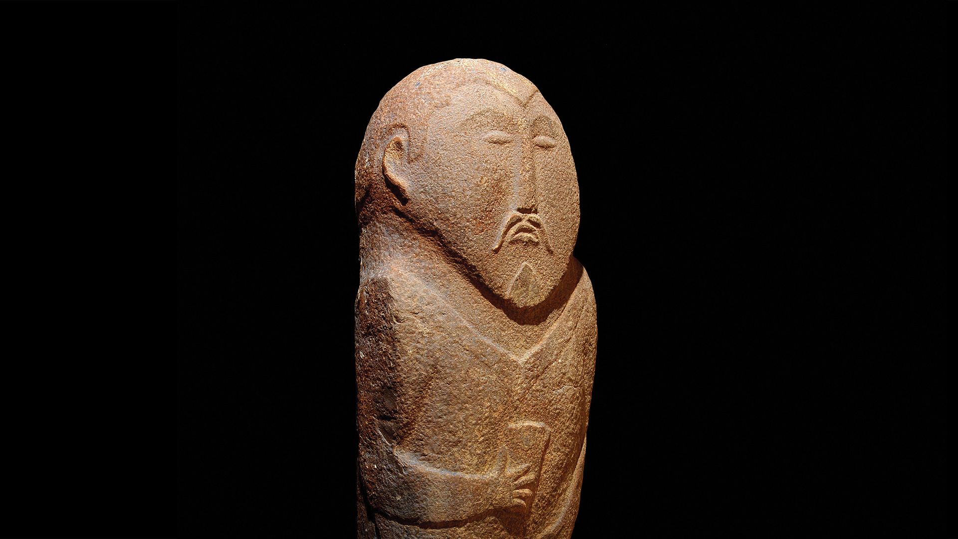
The Kypchak Khanate left a significant number of cultural monuments. Among them, "balbals" — stone statues — have gained particular fame. The the art of making balbals reached its heyday in the Kypchak era.
Kypchaks maintained close relations with the Russian principalities, where they became known as the Kumans. Russian chronicles are very informative about trade, armed conflicts, foreign relations and economic structure of the Kypchak tribes.
As the era of the Mongol conquests began, the tribes of the Kypchak Khanate became the basis of the Jochi Ulus, better known as the Golden Horde.