Меню
The terrain of Kazakhstan is complex and diverse; it includes high mountains, uplands, plains, and lowlands.
The predominant types of terrain are hills, plateaus and uplands - they represent more than half of the territory. About a third of the republic is plains, and 10% is highlands.
On the Mangystau Peninsula in the west of the republic, there is the lowest point - the Karagiye Depression (132 m below sea level), and the highest point is in the southeast - Khan Tengri (6,995 m). The difference between the highest and lowest points is 7,127 m.
Features
Talking about the main features of the terrain of Kazakhstan:
- plain-low-mountain regions prevail here as they occupy mainly the western, northern and central regions of the country;
- highlands occupy a small area and are located in the east and southeast of Kazakhstan;
- the territory has a general slope from south to north and from east to west;
high and low mountains alternate with intermountain valleys and plains.
Types of terrain
The vast territory of Kazakhstan includes quite a few different geographical areas. These are the main ones - mountains and lowlands.
Highlands
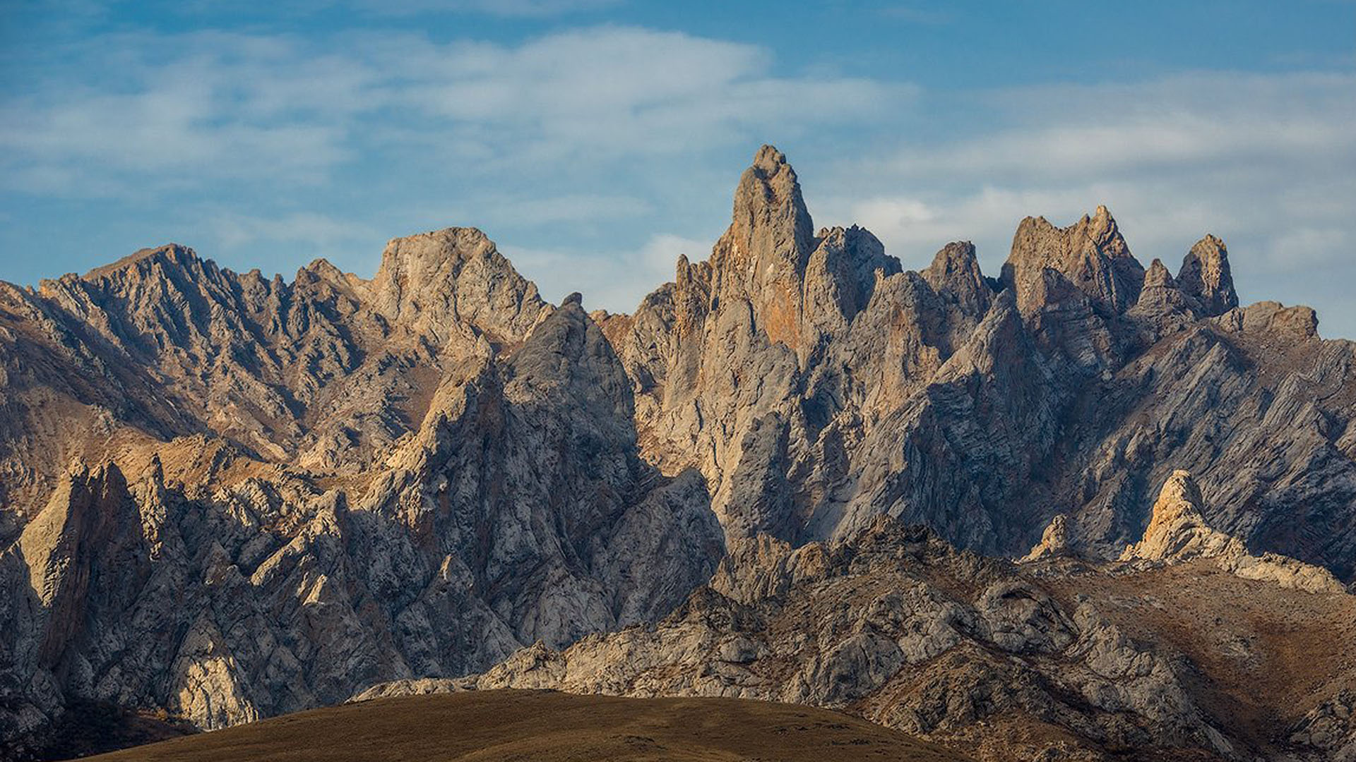
The highlands include: Altai, Saur-Tarbagatai, Dzungarian Alatau and Tian Shan, located on the eastern and southeastern outskirts of Kazakhstan. These mountains were formed in the Paleozoic era and were leveled in the Mesozoic era.
ALTAI
Altai is a mountain system in the south of Siberia. It is located at the borders of Russia, Mongolia, China and Kazakhstan. Its northeastern outskirts includes the southwestern tip of the Altai Mountains. On the state border of Kazakhstan with Russia lies the highest ridge of Altai - Katunsky. Its peak is Muztau (4506 m).
Altai is a part of the largest mountain system called the Altai-Sayan Mountains, it stretches from Lake Zaisan to Lake Baikal. Kazakhstan includes only the southwestern outskirts of Altai. The southern border is the basin of the Black Irtysh River and Lake Zaisan, and the western border is the Kalbinsky Range.
Based on the features of the terrain, the Kazakh Altai is divided into three regions: Southern Altai, Rudny Altai and Kalbinsky Range. Southern Altai is located between the Bukhtarma River in the north, Lake Zaisan and the Black Irtysh River in the south. The Irtysh Valley separates it from the western side of the Kalbinsky Range. In the east, it borders on the Ukok Plateau. Two chains of mountain ranges stretch to the west and southwest. They are separated by the Kurchum and Karakoba rivers.
Rudny Altai consists of Ulba Ridge (2,300 m above sea level), Ivanovsky Ridge (2,775 m above sea level) and the Ubinskiy Ridge (2,100 m above sea level), which are located in the northwest of Southern Altai. They extend from the Katun Range and the Ukok Plateau. Their terrain is varied. Separate parts of the Rudny Altai are strongly dissected and are distinguished by high mountain terrain.
The Kalbinsky Range is located on the left side of the Irtysh River. Its highest point is Mount Saryshoky (1,608 m above sea level). The range borders on Saryarka in the west. The tops of the mountains are oval, the slopes are strongly dissected, some areas are flat.
There are many lakes and rivers in Altai. They originate from mountain snowfields and glaciers. The largest river is the Irtysh. It originates in China and flows between the Kalbinsky and Narym mountain ranges. The rivers Bukhtarma, Kurchum, Uba, Ulba and others flow into it. Altai is also rich in lakes. The largest lakes are Zaisan (1.8 thousand sq. km, depth - up to 10 m) and Markakol (455 sq. km, average depth - 14.3 m).
SAUR-TARBAGATAI
Saur-Tarbagatai is a mountain system located in the East Kazakhstan region on the border with China. Its eastern part adjoins the well-known Kazakh hills, Saryarka. To the north of Saur-Tarbagatai lies the Zaisan basin, to the south - the Alakol basin.
The Saur-Tarbagatai mountain system consists of two large mountain ranges - Saur and Tarbagatai. The Saur Range, 140 km long, begins in China, while only its relatively short northern part, 60-65 km long, is located in Kazakhstan. The ridge stretches to the west between deep, large basins. The highest point of Saur is Muztau (3,816 m).
Tarbagatai, as several low mountains, is located next to the Saur Range. They are separated by the rivers Kandysu and Upper Emel (China). Tarbagatai is lower than Saur, but longer - it extends for 300 km. The highest point is Tastau (2,992 m).
Dzungarian Alatau
Dzungarian Alatau (also known as Zhetysu Alatau, Semirechensky Alatau) is a mountain range in the eastern part of Kazakhstan, the northern and northwestern continuation of the Dzungarian mountain system. It stretches from west to east between the Alakol basin in the north and the riverbed of the Ili in the south. Its length is 450 km, the width is 100-200 km. The main massif of the Dzungarian Alatau with a height of more than 4000 m is divided into two parallel ridges - the Northern and Southern. The highest point is Mount Besbakan (4,622 m).
Between the Dzungarian Alatau and the Barlyk ridge, near the China–Kazakhstan border, lies the Dzungarian Gate
The Dzungarian Gate are a narrow tectonic crack, a mountain pass between the Dzungarian Alatau from the west and the Barlyk ridge from the east, connecting the Balkhash-Alakol basin and the Dzungarian Plain. It is a flat and wide (more than 10 km) corridor about 50 km long, along the state border between Kazakhstan and China. The height is 300-400 m. There are lakes Alakol (from the north) and Ebi-Nur (from the south). In the central part of the passage there is the Dostyk railway station, in the southern part there is the Alashankou station of the Lanzhou-Xinjiang railway.
Tian Shan Mountains
Tian Shan is a large mountain system, a part of which is located in the southeast of Kazakhstan. The Tian Shan Mountains are one of the highest in Asia. Its second highest peak and the highest point of Kazakhstan itself - Khan Tengri (6,995 m). This mountain junction, located at the borders of Kazakhstan, China and Kyrgyzstan, is one of the most famous peaks in the world, a dream of almost all climbers.
Kazakhstan includes almost completely the Northern Tian Shan, parts of the Central and Western Tian Shan.
Tian Shan, the Mountains of Heaven in Chinese, is located on the territory of four countries: Kyrgyzstan, China (Xinjiang Uygur Autonomous Region), Kazakhstan and Uzbekistan.
Kazakhstan’s territory includes the Northern Tian Shan and parts of the Central and Western Tian Shan. The Central Tian Shan within Kazakhstan starts from Khan Tengri (7,010 m) and extends to the west through a number of ridges. The largest one is the Terskey Alatau. The border with Kyrgyzstan runs along its eastern branch.
Ranges in the Northern Tian Shan are Ketmen, Kungei Alatau, Zailiysky Alatau, Chu-Ili, and Kyrgyz Alatau.
The Western Tian Shan includes the Talas Ridge and the ridges extending from it in the southeast direction - Ugamsky and Korzhintau. Completely within the boundaries of Kazakhstan is Karatau - the outermost, heavily destroyed region of the Tian Shan.
Lowlands
Saryarka
Saryarka (also known as the Kazakh Uplands, Central Kazakhstan Uplands, Sary-Arka Steppe) is a low-mountain area occupying most of Central Kazakhstan. The capital, Astana, is located in the center of Saryarka, in the upper reaches of the Ishim River.
“Sary Arka” means “yellow range”. In the west, Saryarka borders on the Turgay Plateau, in the east - on the Saur-Tarbagatai mountain system, in the north - on the North Kazakh Plain, in the southwest - on the Turan Lowland. Its length from west to east is 1,200 km, its width in the eastern part is 400 km, and in the western part it is about 900 km.
There are the Karkaraly Mountains (1,403 m) in the center. To the south is the Kyzyltas massif with Mount Aksoran (the highest point of the hillock is 1,565 m).
In the south-west, there are the Ulytau Mountains (1,133 m). In the north, there is the Kokshetau Upland (947 m). In the east, there are Chingiztau (1,077 m) and Akshatau (1,305 m) ridges. Scattered along the outskirts are fairly high isolated massifs (15-30 km): Bayanaul (1,026 m), Degelen (1,084 m), Zhaksy-Zhalgyztau (729 m), Burabay (947 m), Niyaz (833 m), etc.
In the southern part of the small hills, 70 km from Balkhash, there is the Bektau-Ata massif (1,213 m).
The Saryarka area, namely the steppes and lakes of Northern Kazakhstan, became the first natural UNESCO World Heritage Site in Kazakhstan and Central Asia. It was included in the World Heritage List in 2008 at the 32nd Session of the World Heritage Committee in Quebec, Canada.
The very word “Saryarka”, referring to a very important territory for the Kazakh people, has become a sort of symbol in folk culture. Districts in the country's largest cities of Almaty and Astana, as well as other settlements, an airport in Karaganda, and several villages throughout the country were named after Saryarka. In addition, cultural and sports facilities and entertainment centers are often named after it (for example, the hockey club in Karaganda or the largest cycle track in Astana).
Mugodzhar Hills
The Mugodzhar Hills is a low-mountain region, which is a continuation of the Ural Mountains. The Mugodzhar Hills is located in the west of Kazakhstan in the Aktobe region. Their length is 200 km, width — 30 km, average height — 450-500 meters.
The Mugodzhar Hills stretch from north to south from Orsk (Orenburg Oblast, Russia). The highest points are the Big Baktybai (657 m) and Airyk (633 m).
The Or river (left tributary of the Ural River) originates from the Mugodzhar Hills, the Emba River and its tributaries to the west, and the Irgiz River to the east. There are the Big Badgers sands to the south of the Mugodzhar Hills, separating them from the Aral Sea basin.
Mangystau Mountains
The Mangystau Mountains are located on the Mangyshlak Peninsula of the Caspian Sea. They include the western and eastern ranges of Karatau (117 km); as well as the southern and northern ridges of Aktau (70 km). There are logs, ravines, and narrow gorges.
The Mangystau Mountains are less ancient than the Saryarka, but they have much in common in terms of the structure and nature of the terrain. The highest point of the Mangystau Mountains is Besshoky in the Karatau Range (556 m).
Plateaus and uplands
Ustyurt Plateau
The Ustyurt Plateau is a plateau located on the territory of Kazakhstan, Turkmenistan and Uzbekistan. It enters the territory of Kazakhstan only in the northwestern part and occupies the space between the Mangystau peninsula and the Aral Sea.
The area of the Ustyurt Plateau is about 200,000 sq. km. It is a hilly plain with an average height of 200 m above sea level. The highest point of the plateau on the territory of Kazakhstan is the Muzbel Ridge (340 m). To the northeast, it gradually decreases.
From almost all sides, the Ustyurt Plateau is bordered by sheer cliffs called chinks. The eastern chink, breaking off to the Aral Sea, has a relative height of almost 190 m.
The main landscape is a clayey sagebrush and sagebrush and saltwort desert, the southeastern part of the plateau is a clayey and rubbly desert.
Turgay Plateau
The Turgay Plateau is located between the Southern Urals and the Mugodzhar Hills in the west and Saryarka (Kazakh hills) with the Kokshetau Mountains and Ulytau Mountains in the east.
The length of the Turgay Plateau is about 600 km, the width is 300 km, the height is up to 310 m, the average height is 200-300 m. There is a wide depression (hollow) in its central part extending from north to south for 750 km. It is called the Turgay Strait, or the Turgay Gate. The western and eastern sides of the depression are a dissected cracked plain. The plateau is mainly composed of marine sediments and continental rocks. Their thickness reaches 5,000 meters. The modern terrain is composed of clayey and sandy rocks.
Cis-Ural Depression
Cis-Ural Depression (also known as the Emba Plateau) is a plateau located between the Caspian Lowland and the western Mugodzhar Hills.
The average height of the plateau is about 100-300 meters. In the northeast, it somewhat rises, and to the north, west and south, it lowers and gradually turns into a hilly-ridged plain. The plateau is composed of clays and sandy deposits with outcrops of phosphorites in some places. The Cis-Ural Depression is irrigated by the Emba River and other smaller rivers.
Betpaqdala Plateau
The Betpaqdala Plateau is located between the Sarysu River in the west and Lake Balkhash in the east, Saryarka in the north and the Chu River in the south.
The surface of the plateau is uniform. In some places there are short dry ravines and shallow depressions, occupied by salt marshes and deposited lakes. There are no running waters at all on the plateau. The height above mean sea level of the terrain is 300-350 meters.
Obshchy Syrt
The Obshchy Syrt is a vast hilly-ridged upland (syrt) located between the Volga and the Ural Mountains. Only its small southern part belongs to Kazakhstan. The Obshchy Syrt is composed of limestone, chalk and other sedimentary rocks collected in short low folds in a northwestern direction. The terrain of the upland is dissected, the part in Kazakhstan is more flat.
Balkhash elevated plain
The Balkhash elevated plain is a plain stretching to the south of Lake Balkhash, between the Dzungarian Alatau in the southeast, the Zaili Alatau in the south and the Chu-Ili mountains in the west. A particular feature of the plain is that it rises from 350 to 700 m towards the surrounding mountains. The Balkhash Plain includes sandy deserts of Taukum, Saryesik-Atyrau and Bakanasska, a clayey sandy plain, crossed by numerous dry channels. The terrain of the Balkhash Plain is mostly ridge sands, alternating with dune sands and clayey-sandy areas.
Plains and depressions
The West Siberian Plain (also known as the West Siberian Lowland) is a plain located in Russia and northern Kazakhstan. The southern outskirts of the West Siberian Plain extend to Kazakhstan. It stretches in a narrow strip from the Ural Mountains to Altai.
The plain’s terrain is uniform: there are no hills or uplands. In some places there are low manes or ridges of 5-15 m, elongated in a northeastern direction for 2-8 km. Between those there are shallow depressions, some of which are chains of small lakes.
The West Siberian Plain has a general slope from south to north. In the south, where the plain adjoins Saryarka, it rises to 200 m above sea level, and in the north and northeast (near Petropavlovsk) it drops to 130-140 m. This slope can be seen only by the slow flow of rivers.
East European Plain
The East European Plain (also known as the Russian Plain) is a vast plain in Eastern Europe, an integral part of the European Plain. Kazakhstan is located in its southeastern part, the Caspian Depression.
Caspian Depression
The Caspian Depression is located between the Obshchy Syrt in the north, the Cis-Ural Depression in the east and the Caspian Sea in the southwest. In the southeast, the lowland borders the Ustyurt and Mangyshlak plateaus.
Off the coast of the sea, the Caspian Depression lies 27 meters below sea level. Further away from the Caspian Sea, it gradually rises and on the northern outskirts reaches 100 m of absolute height. The terrain of the Caspian Depression is monotonous. Since it has repeatedly been the bottom of the sea, there are no elevated areas for tens of kilometers. There are most of all flat clay plains and sandy massifs. These include Naryn, Batpaysagyr, Bozanay, Kosdaulet, Myntobe, Taisoigan, Karakum deserts.
Turan Depression (Lowland)
The Turan Depression (Lowland) is a wide plain in Kazakhstan stretching from west to east. While only its northern part lies in Kazakhstan, the lowland is mainly located on the territory of other Central Asian states. The outskirts of the lowland extends to parts up to 200 m above sea level and drops towards the center near the Aral Sea.
The Syr Darya river divides the Turan Lowland into northern and southern parts. Ustyurt and other plateaus with isolated mountains alternate with relative lowlands; individual depressions are located below sea level (for example, Karagiye Depression - 132 m). Most of the lowland is occupied by Karakum, Kyzylkum, Muyunkum deserts and others; the heights are up to 922 meters.